 eAtlas Data Catalogue
Geoscience Australia (GA)
Type of resources
Topics
Keywords
Contact for the resource
Provided by
Years
Formats
Representation types
status
Scale
-
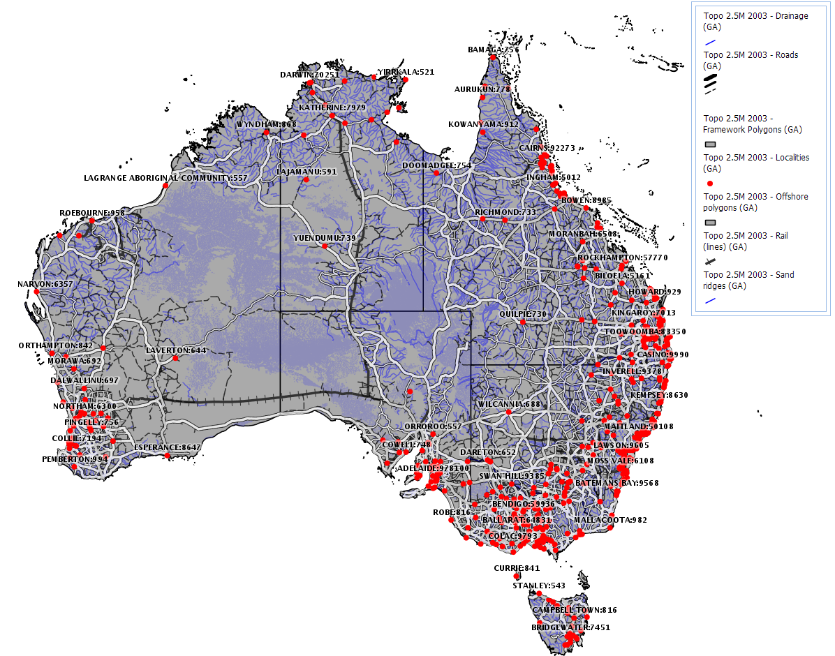
The GEODATA TOPO 2.5M 2003 product is a national seamless data product aimed at regional or national applications. It is a vector representation of the Australian landscape as represented on the Geoscience Australia 1:2.5M general reference maps and is suitable for GIS applications. It supersedes the TOPO 2.5M 1998 product by being developed according to GEODATA standards as described below. The data was derived from GEODATA TOPO 250K Series 2 data where available and GEODATA TOPO 250K Series 1 and has double precision accuracy. The product consists of eleven data layers, including built-up areas, contours, drainage, framework, localities, offshore, rail transport, road transport, sand ridges, spot heights, and waterbodies.
-
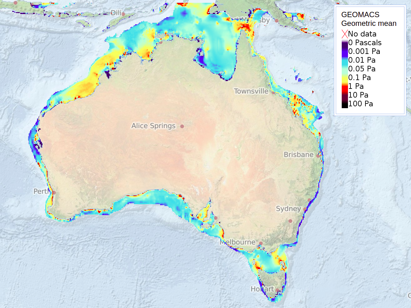
Geoscience Australias GEOMACS model was used to produce hindcast hourly time series of continental shelf (~20 to 300 m depth) bed shear stress (unit of measure: Pascal, Pa) on a 0.1 degree grid covering the period March 1997 to February 2008 (inclusive). The hindcast data represents the combined contribution to the bed shear stress by waves, tides, wind and density-driven circulation. The trimmed mean is simply the arithmetic mean calculated excluding a percentage of the highest and lowest values in the distribution. On this occasion the highest and lowest 25% of model observations were excluded for the calculation. The geometric mean was used alongside the trimmed mean to provide a more robust representation of the bulk of the values than the arithmetic mean would have provided (Hughes and Harris 2008). The Geological and Oceanographic Model of Australias Territory (GEOMAT; Harris et al., 2000) developed at Geoscience Australia provides maps indicative of seabed exposure on the Australian continental shelf in depths between approximately 20 m and 300 m. GEOMAT v.1 proposed a classification of the Australian underwater territory based on sediment mobility induced by distinct processes such as tidal currents and gravity waves (Porter-Smith et al., 2004). GEOMAT v.2 (GEOMACS) proposed an improved classification of the continental shelf area based on a seabed exposure index (Hemer, 2006). The seabed exposure index was derived from the statistical distribution of the sediment transport rate, which reflected the strength and frequency of the combined wave-current bed shear stress. The bed shear stress was derived from a bottom boundary layer model (SEDTRANS - Li and Amos, 2001), which integrated the combined action of tidal currents (Egbert et al., 1994), oceanic currents (OCCAM; Webb et al., 1998), and gravity waves (AUSWAM - Greenslade, 2001) over a given mean sediment fraction (MARS; Geoscience Australia, 2006). Additional Referencs: Egbert, G.D., Bennett, A.F., and Foreman, M.G.G., 1994. TOPEX/POSEIDON tides estimated using a global inverse mode. Journal of Geophysical Research 99, 24821-24852. Greenslade, D.J.M., 2001. The Assimilation of ERS-2 Significant Wave Height Data in the Australian region. Journal of Marine Systems 28, 141-160. Harris, P. T., Smith, R., Anderson, O., Coleman, R., and Greenslade, D., 2000. GEOMAT modelling of continental shelf sediment mobility in support of Australias regional marine planning process. Australian Geological Survey Organisation Record 2000/41. Geoscience Australia, Canberra. 53pp. Hemer, M.A., 2006. The magnitude and frequency of combined flow bed shear stress as a measure of exposure on the Australian continental shelf. Continental Shelf Research 26, 1258-1280. Hughes, M., Harris, P. T., 2008. Progress Report on Disturbance Task C1, Surrogates Program, Marine Biodiversity Hub. Geoscience Australia, Canberra. Li, M.Z., and Amos, C.L., 2001. SEDTRANS96: the upgraded and better calibrated sediment transport model for continental shelves. Computers and Geosciences 27, 619-645. Porter_Smith, R., Harris, P.T., Anderson, O., Coleman, R., Greenslade, D.J.M., and Jenkins, C.J., 2004. Classification of the Australian continental shelf based on predicted sediment threshold exceedance from tidal currents and swell waves. Marine Geology 211, 1-20. Webb, D.J., Cuevas, B.A., and Coward, A.C., 1998. The first main run of the OCCAM global ocean model. Internal Report of James Rennell Division, Southampton Oceanography Centre, UK. 50pp. See also:http://www.noc.soton.ac.uk/JRD/OCCAM. The dataset is estimated on a 0.1deg grid resolution. Output is from a mathematical model; there are no direct field observations. The GEOMACS model does not include the effects of wave breaking and refraction/diffraction or non-linear shallow-water effects on the tide, therefore the model is not considered useful in less than 10 m water depth, and in many regions in less than 30 m water depth; depending on the dominant wave period, tidal range and bathymetric complexity (Hughes and Harris 2008). Conversely, seabed disturbance produced by the wave, tide and current input variables appears not to extend beyond 300 m depth. The temporal domain includes 11 years and therefore contains limited information on events with long return intervals at specific locations, e.g. tropical cyclones (Hughes and Harris 2008). All model outputs data have been visually checked for artefacts and spurious data. Tests conducted to ensure data are reliable and valid. Data Location: This dataset is filed in the eAtlas enduring data repository at: data\non-custodian\2020-2025\AU_GA_GEOMACS-1997-2008\
-
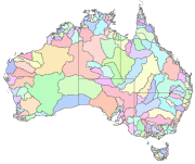
Australia's River Basins 1997 is the result of a joint State, Territory and Commonwealth Government project to create a national spatial database of major hydrological basins. It shows the boundaries of Australia's basins as defined by the Australian Water Resources Management Committee (WRMC). Australia is divided into drainage divisions which are sub-divided into water regions which are in-turn sub-divided into river basins. The data includes the name and number of each of the 245 drainage basins, 77 regions, and 12 divisions. This metadata was prepared for the eAtlas and is not authoritative. Please contact the custodian for an authoritative record. Data Location: A copy of this dataset is filed in the eAtlas enduring data repository at: data\other\AU_GA_River-basins-1997